May 19, 2026
The South African National Space Agency has been working extensively to analyse flood damage following heavy rainfall across the Eastern and Western Cape provinces.
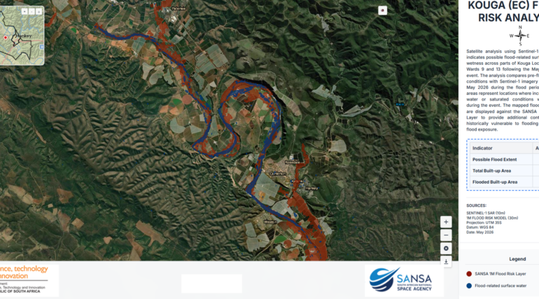
Using Earth Observation satellite-based flood analysis, SANSA identified significant flood-related surface water and saturated ground conditions across portions of the Kouga Local Municipality following the May 2026 rainfall event. The assessment utilised Sentinel-1 Synthetic Aperture Radar (SAR) imagery acquired during the flood period and compared it with pre-event imagery from April 2026 to identify areas where surface water extent increased as a result of the flooding.
The analysis indicates that flood-affected areas were primarily concentrated along river corridors and adjacent low-lying agricultural and settlement zones around Hankey and surrounding communities. These mapped flood extents were overlaid with SANSA’s 1-metre Flood Risk Layer to provide additional insight into historically vulnerable floodplain areas and potential exposure to infrastructure and built-up environments.
Preliminary results indicate a possible flood extent of approximately 261.57 hectares, with an estimated 2.04 hectares of built-up area affected by flooding. The integration of Earth Observation data with flood risk modelling enables rapid situational awareness, supporting disaster response, impact assessment, and informed decision-making by local authorities and stakeholders.
This analysis demonstrates the value of satellite-based monitoring for near real-time flood detection and risk assessment, particularly in regions where persistent cloud cover or limited ground access may limit conventional monitoring approaches.
For detailed reports, maps, or data for other areas, please contact SANSA Customer Services at customers-eo@sansa.org.za or Khumbulani Mkhize at kmkhize@sansa.org.za.