May 14, 2026
The South African National Space Agency has provided an analysis of the Cape Town floods following the devastating disaster that caused significant damage to property and led to loss of lives. SANSA uses satellite Earth Observation intelligence to analyse high risk areas and quantify the extent of damage caused by disasters.
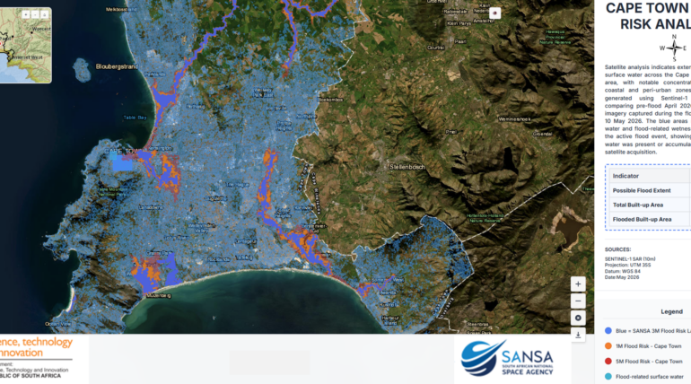
The map presents a flood risk analysis for the Cape Town metropolitan area based on Sentinel-1 Synthetic Aperture Radar (SAR) satellite imagery acquired during the May 2026 flood event. The analysis compares pre-flood conditions from April 2026 with imagery captured on 10 May 2026 to identify areas affected by surface water accumulation and flooding.
The results indicate widespread flood related surface water across large parts of Cape Town, particularly within low-lying coastal plains, river corridors, wetlands, and densely populated peri-urban areas. Flooded zones are concentrated along major drainage systems and urban catchments extending from the northern suburbs through the Cape Flats and towards the False Bay coastline. Significant impacts are also evident around informal settlements and built-up residential areas where poor drainage and flat terrain increase flood susceptibility.
The blue overlay represents the surface water and flood extent layer derived from radar observations, while the orange and red areas indicate modelled flood risk zones associated with 1-metre and 5-metre flood scenarios respectively. The combination of observed flood extent and flood risk modelling highlights areas vulnerable to both current and future flood events.
According to the spatial analysis, the possible flood extent covered approximately 47,690.10 hectares across the study area. The total built-up area within the mapped extent was estimated at 52,639.90 hectares, of which approximately 9,710.91 hectares were identified as flooded built-up areas. This demonstrates the significant exposure of urban infrastructure, settlements, transport networks, and economic activity to flood hazards within the Cape Town region.
The analysis demonstrates the value of Earth Observation and radar-based remote sensing for near real-time flood monitoring, disaster response, and spatial planning. The use of Sentinel-1 SAR imagery is particularly effective because radar sensors can detect surface water regardless of cloud cover or weather conditions, enabling rapid assessment during active flood events. The outputs support disaster management authorities in identifying affected communities, prioritising emergency response interventions, and informing long-term flood mitigation and resilience planning.
To access detailed reports, maps or data over other areas, please contact customer services at customers-eo@sansa.org.za and Khumbulani Mkhize at kmkhize@sansa.org.za